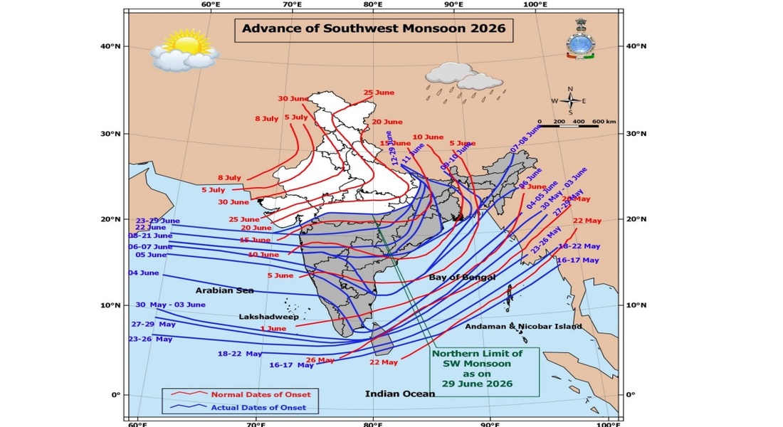

New Delhi, June 29: The India Meteorological Department (IMD) on Monday forecast widespread heavy to very heavy rainfall across large parts of the country over the next seven days as the southwest monsoon continues its advance into northern and central India. Several states are likely to experience thunderstorms, lightning, gusty winds and isolated spells of extremely heavy rainfall till July 5.
According to the IMD’s latest All India Weather Summary and Forecast Bulletin, conditions remain favourable for the further advance of the southwest monsoon into more parts of Gujarat, Madhya Pradesh, Uttar Pradesh, Uttarakhand, Himachal Pradesh, Jammu and Kashmir, Ladakh, southeast Rajasthan and adjoining areas over the next few days. A fresh western disturbance is also expected to affect northwest India from July 2, enhancing rainfall activity over the region.
The weather office has forecast fairly widespread to widespread rainfall over Odisha from June 30 to July 5, with isolated heavy rainfall on June 29-30 and July 5. The state is also likely to witness isolated very heavy rainfall between July 1 and July 4, accompanied by thunderstorms, lightning and gusty winds reaching speeds of 40-50 kmph, gusting up to 60 kmph.
Heavy to very heavy rainfall is also expected over parts of Konkan and Goa, Madhya Maharashtra, Kerala and Mahe, Bihar, Uttarakhand, Himachal Pradesh, Madhya Pradesh, coastal Karnataka, Sub-Himalayan West Bengal and Sikkim, Assam and Meghalaya, and Arunachal Pradesh on different days during the forecast period. Isolated extremely heavy rainfall is likely over Konkan and Goa, Madhya Maharashtra, coastal Karnataka, Odisha, and parts of the northeast on selected days.
The IMD has warned of thunderstorms accompanied by lightning and gusty winds across many regions, including Uttar Pradesh, Rajasthan, Punjab, Haryana, Delhi, Jharkhand, West Bengal, Gujarat, Madhya Pradesh, Telangana, Tamil Nadu, Kerala and several northeastern states. East Rajasthan may also experience thundersqualls with wind speeds of 50-60 kmph, gusting up to 70 kmph on some days, while duststorm activity has been forecast over western Rajasthan between July 2 and July 5.
Despite the advancing monsoon, isolated heatwave conditions are likely to persist over Haryana, Chandigarh and Delhi through June 30 and over East Uttar Pradesh on June 29. However, the IMD has forecast a gradual fall of 4-5 degrees Celsius in maximum temperatures across northwest India by July 4. Maharashtra is expected to witness a temperature drop of 3-4 degrees Celsius by July 3, while temperatures in Gujarat and Madhya Pradesh are also likely to decline gradually later this week.
The weather bulletin noted that heavy to very heavy rainfall with isolated extremely heavy rainfall was recorded in several parts of the country during the past 24 hours. Significant rainfall was reported from Arunachal Pradesh, Assam and Meghalaya, Sub-Himalayan West Bengal and Sikkim, Konkan and Goa, Bihar, Madhya Maharashtra and coastal Karnataka, while Odisha also recorded heavy rainfall at isolated places.
In view of the rough sea conditions, the IMD has advised fishermen not to venture into several parts of the Arabian Sea, Bay of Bengal and the Andaman Sea over the coming days as squally weather and strong winds are expected to prevail across these maritime regions.